|
 |
Home  Gallery2010 - 19Current series Gallery2010 - 19Current series |
 
|
|
| Maps and Legends in Dream Time |
2013 Glover Prize finalist.
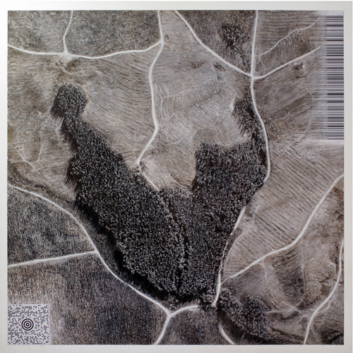 | State Forest/Harford/Tasmania/Australia**
Scott Bennett
Maps and Legends in Dream Time
Acrylic, charcoal, ochre, chalk and collage on clayboard
● Private collection |
|
Simulation is no longer that of a territory, a referential being or a substance. It is the generation by models of a real without origin or reality: a hyperreal. The territory no longer precedes the map, nor survives it. Henceforth, it is the map that precedes the territory - precession of simulacra - it is the map that engenders the territory and if we were to revive the fable today, it would be the territory whose shreds are slowly rotting across the map. It is the real, and not the map, whose vestiges subsist here and there, in the deserts which are no longer those of the Empire, but our own. The desert of the real itself.
(Jean Baudrillard)
Id spent many hours poring over aerial images of Tasmania, on and off for several years. I was mesmerised by the visual patterns of the transformation of wilderness by men and machinery. Reality itself seemed to mock the hubris of this process by projecting ironic pictures. Pale in-roads divide up the landscape and finer branches spread out, creating organic imagery; resembling leaves, flowers or elegant trees.
In some places the landscape had been entirely rationalised by bulldozed contours, and ordered plantings. But these signs of modern civilisation also mimic the dots and lines that pattern ancient art, creating the appearance of a symbolic landscape. The measured rows that tattoo the earth like ritual scarring also resemble the barcodes made for machines to read.
Near Harford, the terrain had the appearance of a prescient oracle, constellating history. This readymade is the subject of my artwork. The MaxiCode (Target or Birds-eye) symbol* on the bottom left, encodes a URL containing the coordinates of the site on a map, the location of the real place.
|
I began working on this series, first called Forget me not in early 2009. I'd started looking at aerial images of Tasmania in c2006, having traveled and hiked around it in 2000.
I sought the kind permission of the Tasmanian DPIPWE to make an artwork based on the hand made reproduction of their aerial images. The map data was compiled from a survey shot in 2004/2005.
Attached below are links to the site on online maps. LIST map and Google maps have since been updated but it is worth a look to compare the changes. Flash Earth, at the time of this writing, still shows the forest as I first saw it!
|
* The barcode on the top right also encodes a message.
** Aerial image reproduced with kind permission of Geodata Services Branch, Information & Land Services Division, DPIPWE.
|
| | |
|
|
|
|